
Seismic stratigraphy of the Ross Island flexural moat under the McMurdo-Ross Ice Shelf, Antarctica - A prognosis for ANDRILL drilling
Horgan, H.(1), Naish, T.(2), Bannister, S.(2), Balfour, N.(1), and Wilson, G(3).
1. Antarctic Research Centre, Victoria University of Wellington, P.O. Box 600, Wellington, New Zealand
2. Institute of Geological and Nuclear Sciences, P.O. Box 30368, Lower Hutt, New Zealand
3. Geology Department, University of Otago, PO Box 56, Dunedin, New Zealand
Ross Island volcanic complex began forming with the emplacement of the basaltic shield volcanoes of Mt Bird and Mt Terror between c. 4.6 and 1.3 Ma, though it has developed most significantly over the last 1 Ma during an eruptive phase resulting in the 3794 m high composite vent of Mt Erebus. Throughout this time loading of the lithosphere at the southern end of the Terror Rift by the Ross Island volcanic pile has progressively depressed the crust resulting in a subcircular flexural moat around the periphery of the island.
Multi-channel seismic reflection data collected from the McMurdo-Ross Ice Shelf (MRIS) reveal the stratigraphic architecture of the moat-fill on the south-eastern side of Ross Island. The moat region has accommodated a well-stratified, regionally extensive sedimentary succession of at least 1.2 km below the sea-floor in the deepest part of the depression. Three seismic stratigraphic units are identified that generally thicken and dip towards Ross Island and are bounded by angular (onlap) unconformities. We infer that these 3 units were deposited in accommodation space created during discrete phases of volcanic load-induced subsidence since 4.6 Ma.
The phases of load induced subsidence may have periodically over-deepened the moat, making it likely that the sedimentary fill is relatively continuous and has largely escaped erosion by ice grounding during past glacial expansions of the West Antarctic Ice Sheet (WAIS) and the MRIS. The age relationships provided by radiometric dating of the various volcanic loads imply that the sediments here have the potential to provide a relatively continuous and high-resolution glacimarine record of the past behaviour of the WAIS-MRIS and the climate history of the western Ross Sea region back to ~5 Ma. This stratigraphic record is scheduled to be drilled by the ANDRILL Programme in the austral summer of 2006. From the interpretation of seismic facies we present a stratigraphic prognosis for the proposed drill site.
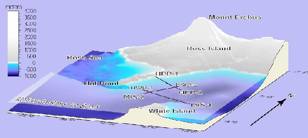 Figure 1. Bathymetry of the Ross Island flexural moat within the study area. The locations of over-ice shelf seismic reflection lines (HPP-1, HPP-2, MIS-1, and MIS-2) and hot water drilling and seafloor sampling sites (HWD-1 and HWD-2) are shown. The hot water drilling sites, HWD-1 and HWD-2, represent 2 possible locations for the ANDRILL McMurdo Ice Shelf drill site. Viewpoint is from 150 degrees at 30 degrees elevation. Topographic data is sourced from the Antarctic Digital Database while bathymetric data is sourced from Geological and Nuclear Sciences archives.