
Plans for the 2004-05 Airborne Geophysical Survey of the Amundsen Sea Embayment, Antarctica (AGASEA)
J. W. Holt, D. L. Morse, D. D. Blankenship
Institute for Geophysics
John A. and Katherine G. Jackson
School of Geosciences, University of Texas, Austin, Texas
D. G. Vaughan
British Antarctic Survey, Cambridge, England
The Ross Sea and Weddell Sea embayments have been the primary focus of attention within the West Antarctic Ice Sheet (WAIS) since the potential for ice sheet collapse and its resulting impact on sea level was first recognized. The Amundsen Sea Embayment (ASE), on the other hand, has been comparatively unstudied primarily due to its remoteness from logistical centers. Recent satellite remote sensing studies, combined with limited ice thickness data, indicate that the ASE discharges the largest ice flux in West Antarctica; furthermore, of all the major drainage basins in Antarctica, it is the only one to exhibit significant elevation change over the period of these satellite observations.
Our present knowledge of the ice thickness and subglacial boundary conditions in the ASE are insufficient to understand its evolution or sensitivity to climate change. Stimulated by observations of its non-steady behavior and its dominant role in WAIS mass balance, the glaciers of the ASE have become a focus for future integrated studies by both the U.S. and European scientific communities, as put forth in the Amundsen Sea Embayment Science Plan (ASESP). This plan has the overarching objectives of assessing the present and predicting the future behavior of the ice sheet in the ASE. In order to accomplish some of the primary ASESP objectives and to guide future surface-based research, the University of Texas (UT) and the British Antarctic Survey (BAS) will undertake a comprehensive aerogeophysical survey encompassing the two major drainage basins within the Amundsen Sea Embayment - Pine Island and Thwaites glaciers. We will conduct this survey during the 2004/05 austral summer, operating from two remote field camps and using two survey aircraft (Figure 1).
The multidisciplinary nature of coupled lithosphere and ice sheet studies requires a broad approach for which multi-instrumented airborne surveys are well suited. Laser surface elevations will enable detailed mass balance calculations and satellite altimeter calibration. Radar sounding data will provide measurements of ice thickness necessary to calculate ice sheet driving stress and hydrologic potential for distinguishing glacier dynamical regimes and to support detailed flow model calculations. Shallow radar layer interpolation will provide ice accumulation rates for mass balance and ice dynamics studies. Internal layer preservation depth will be analyzed for evidence of non-steady flow behavior and will contribute to crevasse classification for evidence of recent non-steady behavior and modern stress state. Detailed basal morphology and roughness statistics will enable interface characterization and complement potential fields data for geologic classification.
Coherent radar echo strength and scattering characteristics will be used for basal interface characterization and basal water detection. Gravity and magnetics data will be analyzed for deep crustal block delineation, sedimentary basin identification, volcanic activity assessment, and geothermal flux estimation, all of which are critical to models of ice sheet dynamics.
The survey design that was proposed required modification due to logistical support limitations. Using the latest estimates of fuel and time available for survey operations, we have developed a strategy that balances coarse coverage of the glacier catchments, higher-resolution coverage of the fast-flow regimes, and along-flow profiles. The 2004 WAIS workshop is an opportunity for the WAIS community to provide feedback on survey design and input on priorities prior to the field deployment which will occur shortly thereafter.
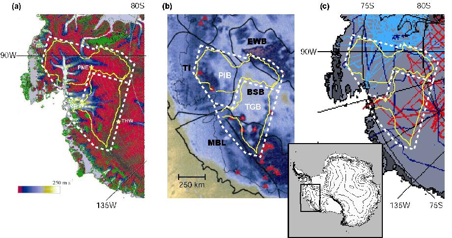 Figure 1: Coverage area of planned ASE aerogeophysical survey shown superimposed on (a) balance velocity and surface elevations contours, (b) bed topography, crustal blocks and recent volcanics (red triangles), and (c) existing data coverage. The survey is subdivided into two sections: the Pine Island Glacier basin (PIB) to be surveyed primarily from field camp PNE, and the Thwaites Glacier basin (TGB) block to be surveyed primarily from camp THW.