
Numerical modelling of the Eurasian ice sheet and its relevance to West Antarctica
Martin J. Siegert
Bristol Glaciology Centre, School of Geographical Sciences, University of Bristol, Bristol, BS8 1SS, UK.
The geography of West Antarctica is strikingly similar to the Eurasian Arctic. Both involve a large continental shelf sea no more than a few hundred meters deep, and both have proximity to a pole and to a continental margin (Figure 1). The major difference is that West Antarctica has a 2.5 km thick ice sheet over it, whereas the Eurasian Arctic is now comparatively free of grounded ice. At the last glacial maximum (LGM), however, the Barents and Kara Seas were covered by a large marine ice sheet which subsequently collapsed prior to the Holocene. The geological remnants of the Eurasian ice sheet, and the ice sheet history reflected in this record, may be critical to evaluating the future of the WAIS.
The interpretation of the geology has varied enormously. While some have claimed evidence for a massive 3.5 km thick ice sheet over the whole of northern Europe at the LGM, others have proposed virtually no ice at all on the sea floor to the north of the Norwegian and Russian mainland. To resolve this issue, two research programmes were organised by the European Science Foundation to gather geological evidence from the land, sea and ocean of the former ice sheet. The first (PONAM: POlar North Atlantic Margins) concentrated on the western margins of the Barents Sea where the ice margin during the LGM was located near the edge of the continental shelf. The area of focus then shifted east to the Russian Arctic during the follow-up programme named QUEEN (QUaternary Environments of the Eurasian North). These programmes allowed the limits of the Eurasian Ice Sheet to be determined with some confidence (Figure 2). The glacial history revealed by the geological investigations was developed further through computer simulations of the ice sheet growth and decay.
Both the PONAM and QUEEN programmes employed ice sheet modelling to provide quantitative details about the size and dynamics of the former ice sheet. The model’s environmental inputs were adjusted until the ice sheet size fitted with the geologically-inferred LGM ice margin (Figure 2). Ice sheet modelling was also used to predict the decay of the ice sheet in a manner consistent with the geological evidence for deglaciation. Deglaciation was actually quite difficult to model at the time when geological evidence reveals ice decay (deglaciation took place early, at around 15,000 years ago, and rapidly as full decay of the Barents Sea was completed within a few thousand years). In order to reconstruct the proper deglaciation, enhanced rates of iceberg calving had to be artificially included in the model (Figure 3), so allowing rapid break up of the ice sheet at the marine margin. The rationale for increasing iceberg calving (or ice loss at the marine margin) is two fold. First, sea level may lead to enhanced rates of calving if the ice is grounded and to enhanced flow as the ice sheet becomes buoyant. Second, if the ocean temperature increases, ice loss at the grounded margin via melting may occur.
At the LGM, grounded ice was probably in place across the whole of the West Antarctic continental shelf, just as it was in the Barents Sea. Ice decay in West Antarctica (from its maximum state to its present condition) was different to the decay of ice in the Barents Sea in two ways. First, deglaciation began much later than in the Barents Sea. Secondly, ice decay in West Antarctica resulted in the formation of large floating ice shelves between the open ocean and the grounded ice sheet. These differences suggest that two conclusions can be drawn about the stability of the West Antarctic ice sheet. First, the ice shelves may be influential in maintaining the stability of the ice sheet because they act as a buttress to support the grounded margin of the ice sheet, whereas in the Barents Sea they may have been absent and the grounded margin was actively involved in iceberg calving. Secondly, given the ice shelf buttressing effect on the ice sheet, the present sea level is not high enough to encourage ice decay in West Antarctica to the extent witnessed in the Barents Sea.
The West Antarctic Ice Sheet is clearly capable of resisting substantial rises in sea-level. The reason for this resistance could be that floating ice shelves in West Antarctica are the key to maintaining grounded ice upstream. It has been well documented that we should be concerned with the stability of the ice shelves in West Antarctica. If they decay, the West Antarctic Ice Sheet will look much more like the former Eurasian Ice Sheet just before it broke up. In this situation, the processes which caused the break up of the marine portions of the Eurasian Ice Sheet (as observed in the geological record) may act over West Antarctica.
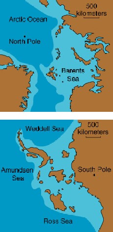 Figure 1. Comparison between the geography of West Antarctica and the Eurasian Arctic.
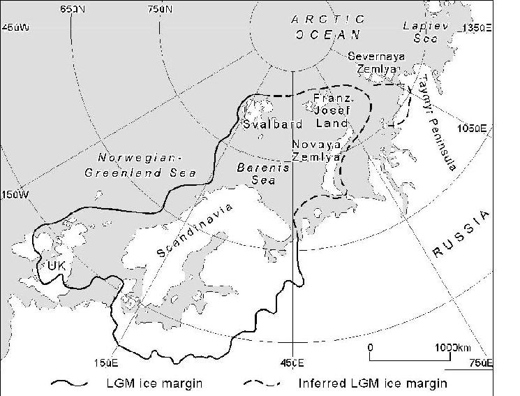 Figure 2. Ice sheet margin of the Eurasian ice sheet at the LGM as determined by the QUEEN programme.
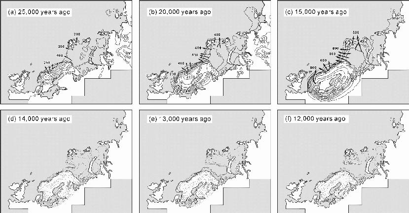 Figure 3. History of the Eurasian ice sheet as predicted by numerical ice sheet modelling.